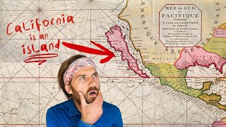
The Biggest Mapping Mistake of 𝗔𝗟𝗟 𝗧𝗜𝗠𝗘
The video explains how California was mistakenly mapped as an island for over 200 years, originating from a 1510 Spanish novel and perpetuated by Hernán Cortés' expedition and Fray Antonio's biased reporting.summaryThis myth spread globally through stolen maps and cartographic confirmation bias, serving as a historical parallel to the modern 'California myth' in Silicon Valley where unrealistic dreams and disinformation drive innovsummaryThe myth of California as an island originated from the 1510 Spanish novel 'Las Sergas de Esplandián,' which described an island populated by black women warriors ruled by Queen Calafia, located 'at the right hand of thetakeaway